What is the best hike in Gatlinburg?
The best hikes near Gatlinburg depend on your skill level: For beginners, Laurel Falls (2.6 mi, paved) leads to an 80-foot waterfall. For moderate hikers, Grotto Falls (2.6 mi) lets you walk behind a waterfall. For advanced hikers, Alum Cave to Mt. LeConte (11 mi) is the iconic Smoky Mountain summit experience with incredible views.
Find Your Perfect TrailBest Gatlinburg Hiking Trails at a Glance
Quick comparison of the most popular trails by difficulty, length, and features
| Trail Name | Distance | Difficulty | Best For |
|---|---|---|---|
| Laurel Falls | 2.6 mi RT | Easy (paved) | Beginners, families, waterfall photos |
| Gatlinburg Trail | 3.8 mi RT | Easy (flat) | Dogs, bikes, strollers allowed |
| Kuwohi (Clingmans Dome) | 1 mi RT | Easy to Moderate | Best panoramic views in park |
| Grotto Falls | 2.6 mi RT | Moderate | Walk behind waterfall |
| Chimney Tops | 4 mi RT | Moderate-Hard | 360° views, iconic rock outcrop |
| Alum Cave to Arch Rock | 2.8 mi RT | Moderate | Unique rock formations |
| Rainbow Falls | 5.4 mi RT | Moderate | Tallest single-drop waterfall |
| Mt. LeConte via Alum Cave | 11 mi RT | Strenuous | Epic summit experience |
| Charlies Bunion | 8 mi RT | Strenuous | Dramatic cliff viewpoint |
| Ramsey Cascades | 8 mi RT | Strenuous | Tallest waterfall (100 ft) |
Trail Status & Best Season to Hike
When to hike each trail for the best experience. Clingmans Dome road is closed Dec - March; high-elevation trails may have ice into April.
| Trail | Best Months | Seasonal Notes |
|---|---|---|
| Laurel Falls | Apr - Nov | Year-round possible; avoid ice in Jan - Feb |
| Grotto Falls | Apr - Oct | Peak flow after rain; summer crowds |
| Kuwohi (Clingmans Dome) | Apr to Nov | Road closed Dec 1 to March 31; fall colors spectacular |
| Chimney Tops | Apr - Nov | Steep; avoid when wet or icy |
| Alum Cave / Mt. LeConte | May - Oct | High elevation; check weather; lodge open Apr - Nov |
| Rainbow Falls | Apr - Oct | Best after rainfall for full cascade |
| Charlie's Bunion | May - Oct | AT section; exposed; avoid thunderstorms |
| Ramsey Cascades | Apr - Oct | Longest trail; spring wildflowers, fall colors |
Great Smoky Mountains National Park contains over 800 miles of hiking trails, making it one of the premier hiking destinations in the eastern United States. The trails range from flat, paved paths suitable for strollers to rugged backcountry routes that challenge experienced hikers. This guide covers the best trails near Gatlinburg, organized by difficulty level.
Trail Parking Update (2026)
Since March 2023, the Park It Forward program requires a parking tag year-round for any vehicle parked longer than 15 minutes inside the national park. Rates are $5 daily, $15 weekly, or $40 annually. Tags are available online at recreation.gov or at park visitor centers (Sugarlands and Oconaluftee are the closest to Gatlinburg). Your cabin driveway does not count, so plan ahead before your first trailhead morning.
Easy Trails (Great for Families)
Laurel Falls Trail
The most popular trail in the park leads to an 80 foot waterfall. The paved path has a moderate incline but is suitable for most fitness levels. Go early morning (before 8 AM) to avoid crowds and find parking. The falls are spectacular after rain.
Gatlinburg Trail
One of only two trails in the park allowing pets and bicycles. This peaceful riverside path connects downtown Gatlinburg to the Sugarlands Visitor Center, following the Little Pigeon River through the forest.
Sugarlands Valley Nature Trail
A paved loop near the Sugarlands Visitor Center, perfect for families with young children or those with limited mobility. Interpretive signs explain the forest ecology.
Kuwohi (formerly Clingmans Dome) Trail
A short but steep paved walk to the highest point in Tennessee (6,643 feet). Officially renamed Kuwohi (pronounced koo-WHOA-hee, meaning "mulberry place") in September 2024 to honor the Cherokee name for the peak. The spiral observation tower offers 360 degree views into seven states on clear days. Kuwohi Road is closed December 1 through March 31 each year.
Moderate Trails
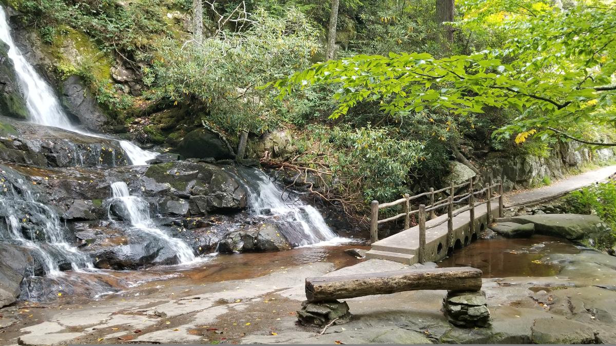
Grotto Falls Trail
The only waterfall in the park you can walk behind. The trail winds through old growth hemlock forest before reaching the 25 foot cascade. Best visited in morning light. Watch for llamas carrying supplies to LeConte Lodge!
Alum Cave Trail (to Arch Rock)
Experience incredible geological formations without committing to the full LeConte hike. Pass through Arch Rock, a natural tunnel carved by centuries of water erosion, and walk along Inspiration Point with stunning views.
Chimney Tops Trail
A steep climb to one of the most iconic viewpoints in the park. After fire damage and restoration, a new viewing platform offers spectacular 360 degree mountain views. The final section is steep and rocky.
Rainbow Falls Trail
The tallest single drop waterfall accessible by trail in the park. On sunny winter days when spray freezes, rainbows appear in the mist, giving the falls its name. Continue past the falls to reach LeConte Lodge.
Rest Your Legs in a Mountain Cabin
After a day on the trails, soak in a private hot tub with mountain views. Our cabins are minutes from the trailheads.
Challenging Trails
Mount LeConte via Alum Cave
The most popular route to the third highest peak in the Smokies. Features Arch Rock, Alum Cave Bluffs, cable handholds on exposed cliffsides, and LeConte Lodge at the summit. Start early and bring plenty of water and snacks. This is a full day adventure.
Charlies Bunion
Starting from Newfound Gap, this section of the Appalachian Trail leads to one of the most dramatic viewpoints in the park. The rocky outcrop (named after Charlie Conner, whose bunioned feet were a running joke among hiking companions) offers heart stopping views into North Carolina.
Ramsey Cascades
The tallest waterfall in the national park at 100 feet. The trail passes through magnificent old growth forest with some of the largest trees in the park. Rocky and rooty in sections. The waterfall is worth every challenging step.
When to Hike: Smoky Mountain Seasons
Great Smoky Mountains National Park is open year-round, but each season changes what is possible on the trails.
- Spring (March to May): The best season for waterfalls. Snowmelt and spring rain put Laurel Falls, Rainbow Falls, Grotto Falls, and Ramsey Cascades at peak flow. Wildflowers carpet the lower valleys from mid-April through mid-May, and the annual Spring Wildflower Pilgrimage runs April 22 to 25, 2026.
- Summer (June to August): Warm and humid in town, but consistently 10 to 20 degrees cooler at the higher elevations. Plan to be off exposed ridge trails like Chimney Tops and Charlies Bunion by early afternoon to avoid pop-up thunderstorms.
- Fall (September to early November): The signature hiking season. Cool mornings, dry trails, low bug counts, and spectacular color from late September at the highest elevations through early November in the valleys. See our visiting Gatlinburg in October guide for the full breakdown.
- Winter (December to February): Low elevation trails like Laurel Falls and the Gatlinburg Trail remain hikeable most days. Higher elevation trails can have ice and snow, and Kuwohi Road closes December 1 through March 31. Hike with traction devices and check current conditions at the Sugarlands Visitor Center before heading out.
How to Pick the Right Trail for Your Group
The most common mistake first-time visitors make is over-committing on day one. The Smokies' steep grade catches even experienced hikers off guard. A few quick rules of thumb:
- For couples on a romantic getaway: Laurel Falls or Andrews Bald in spring, Grotto Falls in summer, Kuwohi at sunset in fall.
- For families with kids under 10: Sugarlands Valley Nature Trail (0.5 mi), the lower Laurel Falls (turn around any time), and the Gatlinburg Trail (flat, dogs allowed). Skip Chimney Tops with small children.
- For larger cabin groups with mixed fitness levels: Drive Cades Cove Loop with frequent stops, then split off for short walks like Abrams Falls (5 mi RT) for the strongest hikers and the John Oliver Cabin loop for everyone else.
- For first-time Smoky Mountain hikers in good shape: Alum Cave Trail to Arch Rock or Inspiration Point is the ideal "Smokies sampler" with a manageable distance and dramatic scenery.
- For experienced hikers: Mount LeConte via Alum Cave is the iconic full day in the Smokies; Charlies Bunion is the second-best ridge-walk experience.
Parking, Permits, and Trailhead Logistics
Most popular trailheads near Gatlinburg fall inside Great Smoky Mountains National Park, which means a Park It Forward parking tag is required year-round for any vehicle parked longer than 15 minutes. Tags are $5 daily, $15 weekly, or $40 annually. Buy them in advance at recreation.gov to avoid lines, or pick one up at the Sugarlands Visitor Center on your way to most trailheads.
Popular trailhead parking lots fill quickly. On October and summer weekends, Alum Cave, Laurel Falls, Grotto Falls (along Roaring Fork), and Cades Cove typically fill by 8 to 9 AM. If you arrive later, you may be redirected to overflow parking or asked to come back. The simplest fix is starting earlier than feels reasonable; a 6:30 AM departure from a Gatlinburg cabin puts you at the trailhead at sunrise with the lot to yourself.
Day hiking does not require a permit. Backcountry overnight camping requires a separate permit reservation through the park's backcountry office.
Cell Service, Maps, and Navigation
Do not rely on phone service inside the park. Most of the popular trails have spotty to no cell coverage. Download offline maps from AllTrails Pro or Gaia GPS before you leave the cabin, and grab a paper trail map from any visitor center. Trail junctions are typically signed, but some lesser-used trails (Porters Creek, Old Sugarlands, Twentymile) require basic map reading.
Wildlife You'll See on Smoky Mountain Trails
The Smokies are home to roughly 1,500 to 1,600 black bears, around 200 species of birds, white-tailed deer, wild turkeys, raccoons, salamanders (the Smokies have more salamander species than anywhere else on Earth), and a small reintroduced elk herd on the North Carolina side. Black bear encounters on hiking trails are uncommon but possible, especially in early summer and fall. Standard rules: stay at least 50 yards (150 feet) away, never feed or approach, make noise as you hike, and pack out all food and trash. If a bear approaches, back away slowly and make yourself look larger. The park's "BearWise" page is a great pre-trip read.
Best Cabins as a Hiking Base Camp
The right cabin makes long hiking days dramatically easier. Look for a cabin with covered parking (helpful for muddy boots), a washer and dryer, a deep tub or hot tub, and a full kitchen so you can pack lunches in the morning and grill at night. Cabins like Serenity, Million Dollar View, and Big Sky Lodge are all within 10 to 20 minutes of the most popular Smoky Mountain trailheads.
Hiking Safety Tips
- Start early. Trailhead parking fills quickly, especially on weekends. Arrive before 8 AM at popular trails.
- Check weather. Conditions change rapidly in the mountains. Pack layers and rain gear, and watch for afternoon thunderstorms June through August.
- Bring water. At least 2 liters for longer hikes. There are no safe water sources on most trails; filter or treat anything you collect.
- Stay on trails. Off-trail hiking damages fragile ecosystems and is unsafe in steep, root-tangled Smoky Mountain terrain.
- Bear safety: Make noise on trails, never approach bears, store food in your daypack, and back away slowly if you encounter one. Stay 50 yards away minimum.
- Tell someone. Share your hiking plans and expected return time with someone back at the cabin, especially for longer hikes.
- Be honest about your fitness. The mountains are steeper than they look. A 4-mile Smoky Mountain hike can take twice as long as a 4-mile hike at home.
- Watch for ice on shaded sections December through March, even when temperatures downtown feel mild.
People Also Ask About Hiking Near Gatlinburg
Laurel Falls Trail is the easiest waterfall hike near Gatlinburg. The 2.6-mile roundtrip paved trail leads to a beautiful 80-foot waterfall. It has a moderate incline but no stairs or rough terrain. Arrive before 8 AM to avoid crowds and secure parking. The trail is suitable for most fitness levels including older adults and children who can walk the distance.
Yes, the park is home to about 1,500-1,600 black bears. While bear sightings on trails are possible, they're more common at Cades Cove. If you encounter a bear: stay at least 50 yards away, never feed or approach them, make noise to alert them to your presence, and back away slowly if one approaches. Bears are generally shy and avoid humans.
Start hiking before 8 AM for the best experience. Early starts mean easier parking at popular trailheads, fewer crowds on trails, cooler temperatures in summer, and better wildlife viewing chances. For long hikes like Mt. LeConte, start at dawn to allow plenty of daylight. Afternoon thunderstorms are common in summer, so finishing by early afternoon is wise.
Yes, several relatively flat trails exist:
- Gatlinburg Trail (3.8 mi) - Flat riverside path, pets and bikes allowed
- Sugarlands Valley Nature Trail (0.5 mi) - Wheelchair accessible, paved loop
- Kephart Prong Trail (4 mi) - Gentle grade along a creek
- Porters Creek Trail (4 mi) - Easy grade through old-growth forest
Your Perfect Hiking Base Camp
Our cabins are minutes from trailheads. Soak in your private hot tub after a day on the trails. Book direct and save up to 15%!
View All CabinsExplore More Guides
Plan your complete Gatlinburg adventure.